
3D Modeling

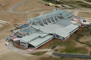

At CDM Drones, photogrammetry is at the core of how we turn aerial imagery into precise, measurable, and highly detailed digital models. Using advanced drone technology and specialised processing software, we capture hundreds of overlapping high-resolution images and transform them into accurate 2D maps and 3D models. Built on our Capture. Data. Model. approach, photogrammetry provides businesses with a powerful, data-rich representation of their sites—enabling better planning, analysis, and decision-making.
High-Accuracy Mapping & Modeling
Photogrammetry allows us to produce detailed orthomosaic maps, 3D models, and point clouds with survey-grade accuracy. These outputs provide a true-to-scale representation of your site, making it easier to measure distances, areas, and volumes directly from the data.
For example, construction teams can use these models to calculate stockpile volumes, monitor earthworks, and verify site levels against design plans—reducing reliance on manual measurements and improving overall accuracy.
Faster Data Collection, Greater Efficiency
Traditional surveying methods can be time-intensive and require significant on-site resources. With drone-based photogrammetry, large areas can be captured quickly and efficiently, often in a fraction of the time.
This means businesses can access up-to-date site data faster, helping project managers make timely decisions and keep operations moving without delays. For companies managing multiple sites, this efficiency translates into significant time and cost savings.
Improve Planning & Project Control
Photogrammetry provides a clear visual and data-driven foundation for planning and managing projects. By working with accurate 3D models and maps, teams can better understand site conditions, identify potential challenges, and plan with confidence.
For instance, developers and engineers can use photogrammetry data to assess terrain, design layouts, and track changes throughout the lifecycle of a project. This ensures greater control over progress and reduces the risk of unexpected issues.
Safer Site Analysis
Safety is a key advantage of photogrammetry. By capturing data from above, CDM Drones eliminates the need for personnel to access hazardous or hard-to-reach areas.
Whether inspecting steep terrain, active construction zones, or large industrial sites, businesses can gather the information they need without exposing teams to unnecessary risk—improving both safety outcomes and operational efficiency.
Versatile Applications Across Industries
Photogrammetry is a flexible solution that supports a wide range of industries, including construction, infrastructure, mining, agriculture, and environmental management.
-
Construction: Track progress, measure volumes, and compare as-built conditions to design plans
-
Mining & Aggregates: Monitor stockpiles, calculate volumes, and manage site operations
-
Agriculture & Land Management: Map land, analyse terrain, and monitor changes over time
-
Infrastructure: Plan and assess roads, utilities, and large-scale developments
By adapting to each project’s unique requirements, CDM Drones ensures you get the most value from your data.
Better Data, Better Decisions
Photogrammetry transforms raw imagery into meaningful insights that are easy to access and share. Our deliverables—including orthomosaics, 3D models, and point clouds—can be integrated into existing workflows and shared with teams and stakeholders.
This ensures everyone is working from accurate, up-to-date information, improving collaboration and enabling faster, more informed decision-making.
Why Choose CDM Drones?
With a commitment to Clarity. Detail. Mastery., CDM Drones delivers photogrammetry solutions that provide precision, efficiency, and reliability. Our advanced technology and experienced team ensure that every project is captured and modeled to the highest standard.
By choosing CDM Drones, businesses gain access to powerful visual and data-driven tools that improve planning, reduce risk, and provide a competitive edge in today’s fast-moving industries.