
Case Studies
Club Saphire Merimbula

March

May

July
A Smarter Way to Track Progress
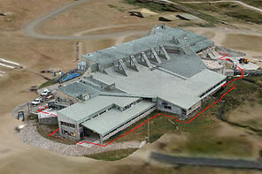
CDM Drones partnered with Club Sapphire Merimbula to deliver ongoing photographic documentation of their new concrete building development. Through scheduled monthly site visits, we captured high-quality aerial imagery to provide a clear, consistent record of construction progress.
This approach allowed stakeholders to track key milestones, monitor structural development, and maintain visibility across the project without the need for constant on-site presence. By delivering reliable, time-stamped visuals at each stage, we helped support project reporting, improve communication, and create a valuable visual archive of the build.
Our consistent capture methodology ensured each set of images aligned with previous visits, making it easy to compare progress over time and identify changes across the site.
3D Model of Perisher Center

Zoom
Overview

Zoom x 2
Increased accuracy, increased safety, increased affordability....
CDM Drones delivered a high-resolution 3D model of the Perisher Centre, providing a detailed and accurate representation of the site and surrounding environment. Using advanced photogrammetry techniques, we captured and processed aerial imagery to create a precise, data-rich model that can be explored, measured, and analysed from any angle.
The model allows builders, inspectors, planners or anyone from the company to better understand the layout, scale, and spatial relationships of the site without the need for constant on-ground access. This is particularly valuable in alpine environments like Perisher, where conditions and accessibility can be challenging.
By transforming aerial data into an interactive 3D model, CDM Drones helped improve planning, communication, and overall project visibility—delivering a clear and practical tool for both internal teams and external stakeholders.
Quarry Traffic and Safety Map

Turning complex quarry operations into clear, safe movement.
CDM Drones delivered a detailed safety and traffic management map for an active quarry, designed to improve on-site awareness, operational efficiency, and risk management. Using high-resolution aerial imagery and accurate spatial data, we created a clear, easy-to-understand map outlining haul roads, access routes, first aid, and key site features.
The map was developed to support safe vehicle movement across the site, helping operators identify designated routes, manage traffic flow, and reduce the risk of incidents. Speed zones, entry and exit points, and high-risk areas were clearly defined, providing a practical tool for both daily operations and site inductions.
By combining accurate aerial data with clear visual communication, CDM Drones delivered a solution that enhances safety, improves coordination, and provides a reliable reference for all personnel working on site.